

East Houston Street is the driver in Manhattan, dividing the club of streets with names of southern Manhattan Island from the fraternity of streets with numbers (and a few letters) on the island north of it. At E. Houston, Columbia becomes Ave. D; Pitt becomes Ave. C; Clinton becomes Ave. B; Essex, Ave. A; Allen, 1st Ave.; and Chrystie, 2nd Ave.. West of that, no numbered avenue gets as far south as Houston except 6th, and it didn’t do so until 1928, long after the overall grid pattern was set.
E. Houston St. has been monkeyed with repeatedly since it was first laid out in the early- 9th century, though most of the shenanigans have gone on during the 20th century. Before 1933 or so, it was a narrow two-lane street, comparable in width to Stanton, Rivington and Broome. In the early-1930s, most—though not all–of the buildings on the south side of the street were condemned between Essex and the new 6th Ave. southern extension so that the IND subway (now the F train) could be built more easily under the street. That, though, left Houston with a lot of empty lots that were filled with transient structures and shacks until a general street widening, making Houston the roaring throughfare it is today, was begun in 1957 and completed in 1961.
Houston doesn’t run parallel to the east-west street grid that it partitions from downtown. Both E. 1st St. and E. 2nd St. run into it before Houston St. itself is brought to a close at the FDR Dr. This situation makes for some unusual parks and triangles, a couple of which we’ll see here.
A quirk in the street grid layout brings 1st Ave, and E. 1st St. together just a nick north of Houston. Nearby, 2nd Ave. and E. 2nd also intersect. That’s the sum total of intersections in Manhattan with the same number. There are none in the Bronx or Staten Island; Brooklyn has a few in Park Slope; and Queens, with its overwhelming street numbering, has dozens.
First Park occupies a substantial part of the wedge of land west of 1st Ave. between E. Houston and E. 1st. It first opened in 1935 and was substantially renovated, with a new kiddie playground, in June 1997, when then-NYC Parks Commissioner Henry Ster gave it its present name. Stern, who was fond of quirky or esoteric names, gave it a new, obvious name, after the dominant number in the area.
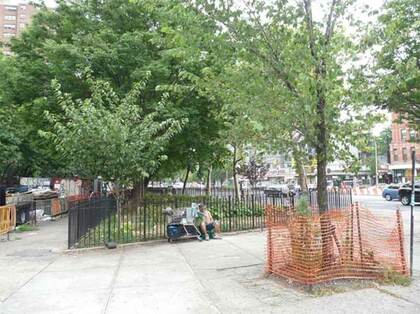
Peretz Sq. is the narrow green spit east of 1st Ave. filling the triangle as E. 1st St. gradually succumbs to running into E. Houston and ending before it reaches Ave. A. The “square” was named in 1952 for Isaac Loeb Peretz (1851-1915), an attorney, author, essayist and poet born in Poland under Russian rule. He wrote primarily in Yiddish and was known as the “Great Educator” of the Jewish masses.
You wouldn’t think you’d find a 1st Ave. or St. in the Bronx, given that 3rd Ave. is the only one of Manhattan’s north-south numbered avenues that extends onto the mainland borough, and it’s spelled “Third Avenue,” not “3rd Avenue” on nearly all the street signs; and numbered streets begin with E. 132nd.
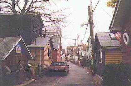
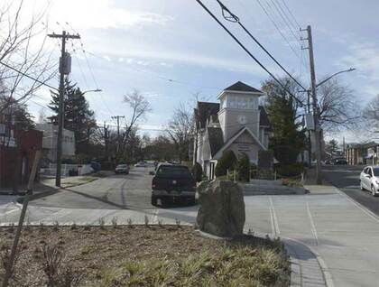
However, New York’s most obscure 1st Ave. is located in the private Bronx neighborhood of Edgewater Park, which is wedged north of the Throgs Neck Expressway and south of Eastchester Bay. Edgewater Park is so obscure that it wasn’t even represented correctly on maps until the 1990s, when Google Maps rendered a mostly faithful version. 1st Ave. winds southeast from Main Street. Houses about the roadway with no sidewalks. Only a couple of roads connect Edgewater Park to its surrounding Throgs Neck neighborhood; 1st Ave. continues around and into the Alden Park section of Edgewater. It’s well protected from the hoi polloi; I got low-res photos of the area in 2000, including this one.
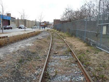
The New York Cross Harbor Railroad still plies 1st Ave. in Sunset Park, Brooklyn from a 50th St. car float pier along 1st Ave. to the Brooklyn Army Terminal and provides New York with a rail freight link to the rest of the North American rail system using a small fleet of car floats. This cross-harbor route eliminates the need to run over 280 extra miles up the Hudson River and then over down the Hudson line. The NYCH primarily serves Long Island via interchange with the New York and Atlantic Railroad at Fresh Pond Yards and southern New England via NYA and CSX/CP, via the New York Connecting Railroad running through Glendale and Jackson Heights, Queens.
The NYCH has two locations: Greenville, NJ where interchange with CSX and NS takes place and Bush Terminal, Brooklyn where interchange with NYA and the South Brooklyn Railway (SBK) takes place. A statue of terminal founder Irving Bush can be found at the yards’ administration building. The NYCH is the result of a consolidation of two Brooklyn waterfront railways. The New York Dock Railway and the Brooklyn Eastern District Terminal (BEDT) merged in 1983 to create the NYCH.
This railroad’s business is primarily moving and interchanging freight cars from New Jersey via car floats. Although there were once dozens of car float bridges along the Brooklyn coast, only one remains in service, just west of 50th St. and 1st Ave. Once tugged over, cars are interchanged with either the New York City Transit Authority via the South Brooklyn Railway or the Long Island Railroad freight division (now the New York and Atlantic RR).
The NYCH also moves a percentage of the nation’s cocoa by floating it from the Brooklyn shipping ports to the mainland. The Cross Harbor delivers car floats to various docks around the Brooklyn port area. In times past, the New York Dock Railway interchanged freight with the New Haven which were responsible for the former electrification of the Bay Ridge freight line. Two car float bridges/gantries of the LIRR in Long Island City have been restored and turned into a recreation area called Gantry Plaza State Park.
Brooklyn has more “First” routes than any other borough. There’s First Ave. and St., E., W., N. and S. 1st Sts., a clutch of Brighton 1st routes in Brighton Beach, First Pl. in Carroll Gardens, and 1st Ct. in Homecrest.
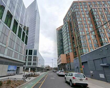
There’s just one 1st St. or avenue in Queens, and it’s within view of the East River between Astoria Blvd. at the Astoria Houses and 26th Ave. at Whitey Ford Field, the west end of Astoria Village. Formerly a backwater lined with one-story warehouses, this outpost has seen construction of massive glassy skyscraper apartment buildings in the 2020s.
New Dorp is a transliteration of Dutch nieuw dorp, or “new town,” so called because it was settled in 1670, ten years after nearby “oude dorp,” a name remembered in the street name Old Town Rd. The town grew up around the junction of Richmond and Amboy Rds., where there were taverns serving stagecoaches and horse-drawn carriages. The Vanderbilt family was prominent in the area and owned several racing and trotting tracks in the area. The family helped found the New Dorp Moravian Church and Cemetery along Richmond and Todt Hill Rds.; the Vanderbilt Mausoleum, built for $1 million and designed by Richard Morris Hunt, is found at the cemetery’s rear section.
Although in the past, there have been other sets of numbered streets in Staten Island, the ones in New Dorp are the only ones remaining, and they’re only 1st through 10th. 5th and 6th Sts. are missing: they’re on either side of the railroad, and New Dorp Plaza stands in for them. Manhattan, Queens, and large portions of the Bronx and Brooklyn feature numbered streets.
There are a pair of historical plaques at the busy junction of 1st St., Richmond Rd. and New Dorp La.. The larger of the two commemorates New Dorp’s World War I dead, while the second, installed by the Daughters of the American Revolution, marks the Rose and Crown Tavern, which stood here during the Revolutionary War. New Dorp figured prominently in the Revolution. Two taverns, about a block apart, were occupied by British officers including commander-in-chief General William Howe. The Rose and Crown was a one-story building with a central hall and rooms on either side, “guarded” by an elm tree. The tree was cut down long ago, but has lent its name to the dead end Elmtree Ave. off Hylan Blvd. and the Elmtree Beacon at New Dorp La. where it meets Raritan Bay. The Rose and Crown stood until about 1865.
—Kevin Walsh is the webmaster of the award-winning website Forgotten NY, and the author of the books Forgotten New York (HarperCollins, 2006) and also, with the Greater Astoria Historical Society, Forgotten Queens (Arcadia, 2013)