

In the Lower Manhattan Financial District, New St. is an obscure alley, now banned to motor traffic, that runs from Beaver St. north to Wall St. just east of Broadway. According to Sanna Feirstein in Naming New York and the late Henry Moscow in The Street Book, it’s not really new: in fact, it’s at least 361-plus years old, as it was the first built street to be named after the British takeover of New Amsterdam in 1664.

This sign, which hung at New St. and Exchange Pl. way downtown, was being auctioned on eBay for $43,000. I doubt such a number will be the final auction price. In 1988, I purchased a similar sign in a lot at 6th Ave. and W. 28th St. for $50. I believe it can get such a price because this one still has its rusty bracket, used on cast-iron posts in the years between the 1910s and 1960s, as well as an attached arrow-shaped one way sign (I’ve seen them with “NY Police Department” on the sign; nonetheless, I think this is authentic). Incidentally, the brackets went with the signs like U goes with Q. Until 2000 or so, one of these sign-bracket combinations was still in place on a telephone pole at an obscure Bronx corner in Eastchester, Allen Pl. at DeLavall Ave.; unfortunately the Department of Transportation made quick work of it. I hope a collector was on hand when they removed it.
Not too many of Kings County’s or any other boroughs’ town halls remain. The history of Kings County’s towns is complicated, but the $2 history is: The county’s original towns were Brooklyn (today’s downtown and stretching east and south as far as Bedford-Stuyvesant and Sunset Park), Bushwick, Flatbush, Flatlands, Gravesend and New Utrecht (New Lots was carved out of the eastern end of the town of Flatbush in 1852), and after a series of secessions and reorganizations, Brooklyn, by then a city, managed to annex all other towns and cities in Kings County in 1896—only to consolidate with Greater NYC in 1898. Thus, Brooklyn became synonymous with Kings County.
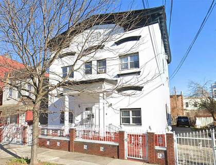
Probably the largest of Kings County’s town halls still standing is the Flatbush Town Hall on Snyder Avenue, but the much smaller New Lots town hall can be found at #109-111 Bradford St. between Fulton St. and Atlantic Ave. in East New York. When opened in December 1873, the building included office space, rooms for public assembly and a fire department, and a police headquarters and jail cells were later added.
Its tenure as a town hall was short-lived as the city of Brooklyn annexed New Lots in 1886. It served as a police precinct for a decade and then became the Bradford Hospital, serving in that capacity until 1934. After that it was divided into residences. Other than the addition of a front wall and fence and a white paint job, it doesn’t look much different than in 1940 and I’m glad this relic of Brooklyn’s towns has been retained. Unfortunately, the Landmarks Preservation Commission has not designated it.
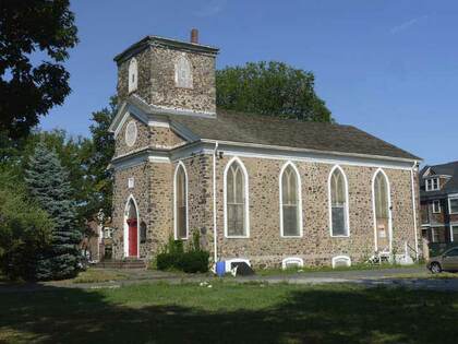
The former town of New Utrecht in southwest Brooklyn is named for Utrecht, Netherlands. In the Dutch colonial era (1626-1664) New Utrecht (pronounced YOU-trekt) was settled by Dutch West India Company director Cornelius Van Werckhoven; after he died unexpectedly, his successor, Jacques Cortelyou, bestowed the name Nieuw Utrecht, after Van Werckhoven’s home, Utrecht. The original town boundaries encompassed today’s Bay Ridge, Borough Park, and Bensonhurst. The ‘town center” of New Utrecht is trisected by three very old roads, two from the colonial era: the Road from New Utrecht to Flatbush, today overlaid by 18th Ave.; the southwest end of Kings Highway (the original Kings Highway was named in the early 1700s and ran from Fulton Ferry south to about today’s Flatbush Avenue and then southwest and west to Denyse Ferry); and the Brooklyn, Greenwood and Bath Plank Road—today’s New Utrecht Ave.. A steam railroad, the Brooklyn, Bath and Coney Island RR, was built along its length in 1864, and that was replaced by today’s West End El in 1917.
The former town center of New Utrecht, at today’s 18th Ave. between 83rd and 84th Sts., is marked by the 1828 New Utrecht Reformed Church, with a beautiful Gothic style and ashlar walls. The church was established in 1677, and the first church building was built in 1700 at about the same time that New Utrecht Cemetery was established on Kings Highway about a quarter mile away at today’s 16th Ave. and 84th St. The present church, only the second in the congregation’s history, was constructed using stones from the original church.
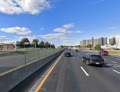
The New England Thruway was built in pieces as part of the interstate highway system in the Bronx, Westchester and the New England states in the mid-1950s. It continues the Bruckner Expressway north of the Hutchinson River Parkway and was opened up to the Connecticut border in 1958. None of the sections of I-95 called the “New England Thruway” are in New England, as once it reaches the state of Connecticut it becomes the Connecticut Turnpike.
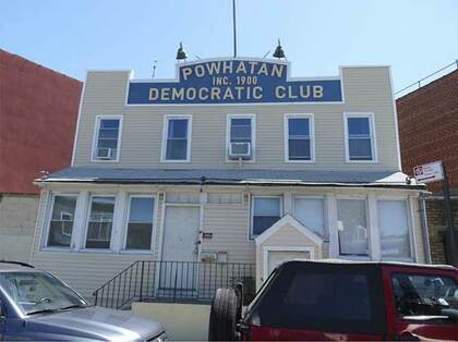
Powhatan Democratic Club, 41-05 Newtown Rd. The political club is now officially known as the Powhatan and Pocahontas Democratic Club. Chief Powhatan (approx. 1547-1618), whose actual name was Wahunsenacah (spellings vary since the Native-American tribal leader didn’t spell his name in English or Roman lettering) was a leader of the Powhatan faction of an alliance of Algonquin people living in what’s now the Tidewater area of Virginia; Powhatan and his daughter, Pocahontas, were encountered by British settler Captain John Smith in 1607. Established in 1900 or 1901 (the sign and the website give different dates) the Powhatan is one of the oldest extant political clubs in the country. The building itself goes back to 1907 or so.
Newtown Rd. isn’t named for the neighborhood where it is, but for the town it runs to; Newtown, a former division of Queens County, is now roughly the neighborhoods of Elmhurst, Middle Village, Maspeth and Glendale. Like a number of NYC streets that run aslant the overall grid, Newtown Rd. is one of the older roads in the area. It’s an Indian trail that became the main road to early Astoria settler William Hallett’s farm in the mid-17th century, and to the treacherous Hell Gate, the East River crossing to Manhattan. Its eastern stretch ended in the heart of Newtown, now Elmhurst, and was called Hurlgate, or Hellgate, Ferry Road; and later named for the town through which it passed, becoming Woodside Ave. The road twisted and turned, to avoid topography like hills and swamps. It was once the sole road between the East River and the heart of Newtown, still the heart of Elmhurst at Broadway and Queens Boulevard.
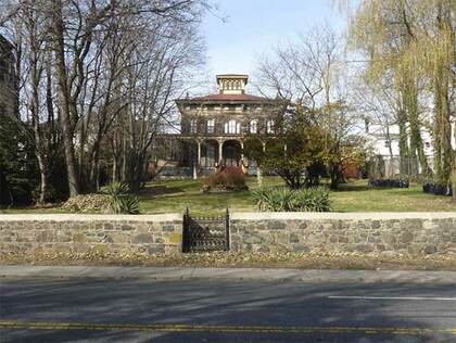
On Richmond Rd. between New Dorp La. and Amboy Rd. in mid-Staten Island is the Gustav Mayer House, an ornate, suburban “villa,” built in 1857 in the Italianate style, set on a knoll with a cupola that offers views of Raritan Bay and a full-width front veranda. For more than a century, until 1990, it was occupied by family members of Gustav Mayer, a wealthy, German-born businessman who was a major innovator in the cookie industry, as the inventor of the Nabisco Sugar Wafer. Much of its Italianate features have remained intact, but a paint job would help.
New Dorp is a transliteration of Dutch nieuw dorp, or “new town,” so called because it was settled in 1670, 10 years after nearby “oude dorp,” a name remembered in the street name Old Town Rd. The town grew up around the junction of Richmond and Amboy Rds., where there were a proliferation of taverns serving stagecoaches and horse-drawn carriages. The Vanderbilt family was prominent in the area and owned several racing and trotting tracks. The family helped found the New Dorp Moravian Church and Cemetery along Richmond and Todt Hill Rds.; the Vanderbilt Mausoleum, built for $1 million and designed by Richard Morris Hunt, is found at the cemetery’s rear section.
—Kevin Walsh is the webmaster of the award-winning website Forgotten NY, and the author of the books Forgotten New York (HarperCollins, 2006) and also, with the Greater Astoria Historical Society, Forgotten Queens (Arcadia, 2013