

Soon after beginning my website Forgotten NY in 1998, I compiled a far-from-comprehensive list of lost streets in Lower Manhattan. I had fun, though I’m not as thorough as Gil Tauber of Oldstreets.com. I’d despaired of ever seeing photographs of these streets, most of which were alleys of little note that the photographers of the period took little interest in. However, a recent development got me in the ballgame once again—the NYC Municipal Archives tax photo series that was uploaded in late 2018. This was an effort to take a picture of every building on every street in NYC. While the streets themselves were not the focus of the program, they do show up incidentally in the pictures, including lost elevated trains, former lamppost styles, etc. It’s a treasure trove of NYC—were I around at the time, I’d likely gotten myself involved with the project. Photography wasn’t as easy then as now, with digital cameras enabling you to take thousands of shots in one outing. In this piece, I’ll show you a few of these really forgotten streets.
Above, we see Batavia St., a short street that ran for two blocks between the equally-vanished Roosevelt and James Sts., a block north of Cherry. Of the two, only a short piece of James St. still exists. The others were wiped out by the construction of the Al Smith Houses in 1948. Smith (1873-1944), a four-time NYS governor and failed presidential candidate, was born on Oliver St., a still-existing street between the Brooklyn and Manhattan Bridges, neither of which had opened when he was born.
Batavia St. seems to be named for a former province in the Netherlands; there’s a town in upstate NY State named Batavia. It’s also the former name of Jakarta, Indonesia, which was part of the Dutch West Indies. NYC streets had names associated with the Netherlands, as the Dutch settled NYC and dominated it until the British takeover in 1664. The signs you see in these photos are the block and lot numbers, as recorded in the Municipal Archives.

There used to be a rabbit warren of short, two-block streets running between Water and South Sts. Most of them have disappeared as they’ve given way to office towers. DePeyster St. ran between Water and South just north of Pine. The lane was eliminated around 1970. Its space is now occupied by the Wall Street Plaza office building and the glassy Continental Center.
Abraham DePeyster (1657-1728) was a Dutch colonial 17th-century New York mayor, serving from 1691-1694, and then as New York governor from 1700-1701. His portrait statue by George Bissel can now be found near Foley Square.

Dutch St., a short passage between John and Fulton east of Nassau, still exists. It’s been almost completely hidden by a construction shed for the last decade. Here’s a 1940 view. Other photos in the Archives show it to have had bars and taverns, which are no longer there today. The street turns up on maps as early as 1776 and was first named around 1789. The Old Dutch Church stood nearby on William between Ann and Fulton from 1769-1875 and the street’s name may derive from it, according to Sanna Feirstein’s Naming New York.


Gouverneur La., in 1940 and in 2013. A lot, except the narrowness of this short street between Water and South Sts., has changed, as four office towers, 95 and 111 Wall Street, and 77 Water and One Financial Square, have all replaced the old brick buildings with window shutters since the 1970s.
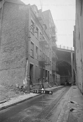
Hague St. ran between Pearl and Cliff, which came to an unusual dead end just north of the Brooklyn Bridge. In the picture we’re looking toward Cliff St. with the Bridge looming at the end of the block. Murray Bergtraum High School and the Verizon Tower (Intergate Manhattan) had taken its place by the 1970s, while the street itself was gone from maps by 1960. The Brooklyn Bridge arch allowing Cliff St. to run under it is still there, but is inaccessible. surrounding streets have been closed for security purposes.

In 1856, the city extended Chambers St. as New Chambers east from Park Row to James St., and at around the same time, built a street connecting Pearl St. with the Bowery at Chatham Square. The former died out, the latter didn’t and survives today as St. James Pl., renamed for Al Smith’s boyhood parish in 1947. New Chambers cut across the prevailing warren of small streets that have since been eliminated. Its presence made for a number of oddly-angled intersections; the same thing survives today in Greenwich Village where 7th Ave. was extended south to accommodate the IRT subway in the 1910’s.
No trace of New Chambers remains today; its roadbed is now occupied by Police Plaza and the Al Smith Houses. The one surviving constant is the Municipal Building, which turns up in many of the archival photos lording over the territory.

I’ve discovered what could be the stub end of Roosevelt Street under the Brooklyn Bridge ramps at South St. The street once extended from Park Row at Baxter southeast to South St. It was obliterated beginning in the 1940s and its space is now occupied by the Chatham Green and Al Smith Houses. Roosevelt Street has nothing to do with Teddy or FDR; the Roosevelts were a prominent NYC family from the late-colonial era and owned property in lower Manhattan, and a street was laid out in those early days and named for the family.
In the above photo, we’re looking at a building on the corner of Roosevelt and Pearl Sts. in 1940. At the time Pearl St. had an elevated train running over it. The el split in two at Chatham Square, becoming the 2nd and 3rd Ave. Els. Nothing in the photo remains except Pearl St. itself and the Municipal Building.

Rose St. exists today, albeit in a form unlike the 1940s. No buildings currently front on it as it merely connects Gold and Madison Sts. under the Brooklyn Bridge and its approach ramps. Before the ramps were built, though, several properties called it home. You can see they are built along the curve that exists on Rose St. to this day. On the right is a high-pressure fire hydrant, once common in Manhattan and older parts of Brooklyn. Most were removed around 2000.

Scammel St., most likely named for Revolutionary War hero Colonel Alexander Scammell, ran from the junction of Grand St. and E. Broadway southeast to South St. near Corlears Hook, where the shoreline of Manhattan curves north. In this photo, we see the intersection of Scammel and Henry and the St. Augustine’s Episcopal Chapel, built in 1829 as the All Saints Free Chapel. PS 134 and the Vladeck Houses occupy its former location today.

Vandewater St. ran from Frankfort St. northeast to where Pearl and New Chambers intersected. The arch it used to get beneath the Brooklyn Bridge is still there, though inaccessible. After it was closed around 1970 much of Murray Bergtraum High School was built atop its old path.
—Kevin Walsh is the webmaster of the award-winning website Forgotten NY, and the author of the books Forgotten New York (HarperCollins, 2006) and also, with the Greater Astoria Historical Society, Forgotten Queens (Arcadia, 2013)