
There are a number of streets around town that transcend borders and run between boroughs, even those separated by water. The greatest frequency occurs in Bushwick, Brooklyn and Ridgewood, Queens, where over a dozen streets cross the undefended border between the two boroughs; and in some cases, as on Wyckoff, Cypress and other avenues, the boundary runs down the center of the street. At Cypress Hills and Woodhaven, a couple of avenues such as Glenmore and Belmont, trickle into Queens for a few blocks, then peter out. Others like Sutter Ave., continue for a few miles, and the champion, Jamaica Ave., continues as Jericho Turnpike and NYS Route 25 to the tip of Long Island in Suffolk County.
In Fordham, Bronx, Park Ave. is a far cry from the urban boulevard between E. 46th and 96th Sts. in Manhattan with its St. Bartholomew Church, Lever Building, and ritzy penthouse apartments. Here, it’s merely a neighborhood street on both sides of the Metro North tracks; when the old NY Central was extended into the Bronx in the 1800s, Park Ave. was laid out alongside it. Originally, the various stretches of Park Ave. here bore names like Railroad Ave. and Vanderbilt Ave., but in 1896 the whole shebang was rechristened Park Ave. Its house numbers follow the sequence that started south at E. 32nd St.

Another renamed stretch of Park Ave. is fairly recent. Park Ave. South has existed under its present name since 1959. Before that, the route was called 4th Ave.; the avenue had been renamed Park from E. 32nd to the Harlem River in 1888 to appease real estate brokers—until that time the avenue had run alongside an open cut serving trains entering and leaving Grand Central Terminal, and it was a gang-ridden region. In NYC, where Park Ave. had developed into a boulevard inhabited by the movers, shakers and the Astor 400, the city thought it was a good idea to try and extend the atmosphere south, and so, the pedestrian “4th Avenue” had to go and Park Ave. South came into existence. A six-block section of 4th Ave. was retained south of Union Square.
Several buildings, however, have retained by attrition reminders of 4th Ave. 295 Park Ave. South and E. 23rd St. was built in 1891, when the “4th Avenue” name was still holding firm.

Imagine my surprise when I learned that Atlantic Avenue, one of the lengthiest streets in NYC, divided about equally between Brooklyn and Queens, had been extended for about a block on its east end. Atlantic Ave. extends from the Brooklyn Heights waterfront east in about a straight line to where the Van Wyck Expressway meets 94th Ave. (at the former LIRR Dunton station). Its history is straightforward: other than short stints as District St. and Atlantic St. when it was first laid out in the early-1800s, as it was extended east, it’s been under the Atlantic Ave. moniker.
The avenue was extended east to accompany the Long Island Rail Road as it ran from Flatbush terminal to Jamaica. The LIRR ran in a very early railroad tunnel beneath the avenue from the waterfront to about Court St. in the 1830s, where it surfaced; Flatbush Terminal was built about 1907, and the railroad has officially emanated from there since then. As for the Brooklyn Heights tunnel, it was sealed up and forgotten about, except for the occasional smuggler or Prohibition rumrunner until the 1980s, when a rail buff, the late great Bob Diamond, rediscovered it; he ran underground tours and had dreams of running a street car line in it until he ran afoul of various city agencies as well as the FDNY.
The LIRR has always been Atlantic Ave.’s calling card and ran in the middle of the avenue as a surface road. West of East New York, the line’s cars were at first pulled by horses as steam engines weren’t allowed west of there; an open cut and elevated line were constructed along the line’s western end in Brooklyn (which are still in use) in the 1880s, but the line ran at grade along Atlantic Ave. from East New York to Jamaica until 1940, when the LIRR tunnel under Atlantic Ave. was completed.
At Atlantic Ave.’s east end at the Van Wyck, its traffic then traveled east on 94th Ave., then a two-lane street. However, in 2020 an eastbound spur was completed that shifted eastbound traffic to 95th Ave., which became one-way east; 94th Ave. then became one-way west. The changes are ostensibly to facilitate traffic heading toward the AirTrain station and the LIRR Jamaica station, but 95th Ave.’s eastern progress ends at 150th St., whereupon station-bound traffic has to turn left and then right on Archer Ave.

All five boroughs have a Main St. and all five have a Broadway. The Bronx’s Broadway, though, is an extension of Manhattan’s Broadway, which has existed from antiquity first as an Indian trail that ran the length of Manhattan Island, then as a colonial trail that was subsequently straightened and widened, taking over the Bloomingdale Rd. that led to the Manhattan village of that name.
The Broadway that begins with Number 1, the International Merchant Marine Building at Bowling Green, has been extended far upstate by a gradual process of street re-namings. The route upstate more or less traces the path of the Albany Post Rd., and by extension, Broadway is a continuous route by way of US 9 north almost to the Canadian border. It’s called Broadway continuously all the way north to Phelps Way (State Route 117) in Sleepy Hollow (North Tarrytown) whereupon the route assumes the name Albany Post Rd.. Route 9 assumes the name Broadway briefly once again in upstate Red Hook and again in Saratoga Springs. Route 9 completes its northern progress at a dead end along the Adirondack Northway (Interstate 87) north of the town of Champlain just south of the Canadian border.
Walking the whole length of Broadway and Route 9 upstate would be a prodigious task—for a plodder like me, it’d probably take an entire season. With pre-planning, for lodging and meals, it could be done, even though some detouring would be necessary since Route 9 encompasses some pretty busy traffic upstate, even though the Thruway and Northway carry the heaviest traffic.
Manhattan’s Broadway is not stopped by the Harlem River; covered by an elevated train, it spans the Harlem between Inwood and Spuyten Duyvil.

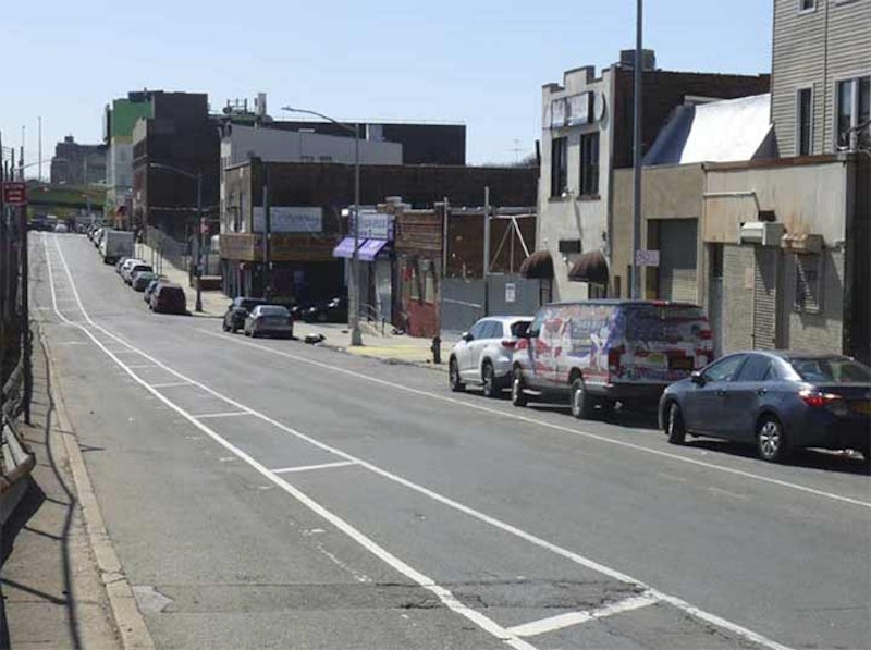
While there are some two-borough streets, modest 95th Ave., seen here at Forbell St. in Cypress Hills, takes the cake, since there are sections not only in Brooklyn and Queens but in Nassau County. The right side of the above photo is Queens; the left side is in Brooklyn, as the borough line runs east on 95th Ave. for two blocks between Eldert La. and Drew St.
From here, 95th Ave. continues on a straight line through Woodhaven, interrupted a couple of times, ending at 150th St. After that, the Long Island Rail Road occupies the space 95th Avenue would, so it doesn’t pick up again until you are near the Queens-Nassau line, running from 222nd St. east to 239th. Because of a quirk in the street numbering, that’s only a five-block stretch, and since the Queens-Nassau line runs roughly, though not exactly, on 225th St., the easternmost three blocks are in Bellerose Terrace, Nassau.
Bellerose Terrace is a small hamlet of about 2000 residences, located in irregular borders, roughly along 225th St., just east of Colonial Rd., Jamaica Ave. at the Long Island Rail Road. Here’s where it gets tricky because just east of here, you’re in the Village of Bellerose in Nassau, and north of Jamaica Ave., you’re in the neighborhood of Bellerose in Queens.
Bellerose Terrace continues Queens’ street numbering scheme in Nassau, including hyphenated house addresses. There are other parts of Nassau that do this, as well, including parts of Elmont (just south of here) and some “unincorporated” bits of Nassau just east of Little Neck formerly had Queens numbering.
—Kevin Walsh is the webmaster of the award-winning website Forgotten NY, and the author of the books Forgotten New York (HarperCollins, 2006) and also, with the Greater Astoria Historical Society, Forgotten Queens (Arcadia, 2013).