

As natural as some parts of Central Park look, every square inch was originated on the planning boards of planners Frederick Olmsted and Calvert Vaux. Inwood Hill Park, at the northern end of Manhattan Island, is 196 acres of primordial forest (with the occasional path and rusting park lamppost). It was the site of Native-American habitation; deer and raccoon were hunted for food and clothing. After the Civil War, prominent families built large mansions here overlooking the Hudson, among them Isidor Straus, who perished aboard the Titanic in 1912, and the Lord family of Lord & Taylor. The area officially became a park in 1926.
Inwood Hill Park contains the last remnant of the tidal marshes that once surrounded Manhattan. The marsh receives a mixture of freshwater flowing from the upper Hudson River and saltwater from the ocean’s tides. The mix of salt and fresh waters, called brackish water, has created an environment unique in the city and the marsh contains wildlife such as fiddler crab and ribbed mussel. The arched Henry Hudson Bridge, opened in 1936 to bring the Henry Hudson Parkway across the Harlem River, can be seen from the park.
The Dyckman St. station on the #1 train, Dyckman St. and Nagle Ave., is among my favorites, because it emerges from a tunnel into the light, like Brooklyn’s Parkside Ave. station and the Hunters Point Ave. station in Queens. Unlike those two statins, though, the Dyckman St. platform is entirely outdoors.
Dyckman’s a big name in upper Manhattan—bookkeeper Jan Dyckman arrived from Westphalia (then under Prussian control) in the late-17th century, married into the Nagle family and gradually controlled much of upper Manhattan. His descendants were prominent US patriots—the British burned down the original Dyckman homestead at what became Broadway and 204th St., and his great grandsons built the farmhouse that still stands today (see below).
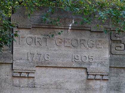
The tunnel’s labeled with the chiseled sign “Fort George 1776 1905.” The first date refers to Fort George, originally Fort Clinton, which was built by US patriots at about where George Washington High School stands at Audubon Ave. and W. 192nd St. Though the British eventually captured the fort, Colonel William Baxter and his Bucks County Pennsylvania militia were able to hold off British general William Howe’s troops long enough for Washington’s troops to escape to New Jersey (much of the Revolutionary War in 1776 in the NYC area consisted of Washington escaping to fight again). The second date refers to the date that the tunnel was completed.
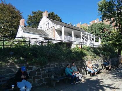
The historical centerpiece of Inwood is the Dyckman Farmhouse at Broadway and W. 204th St., which has been here since about 1785 and is Manhattan’s last remaining Colonial farmhouse. It was built by William Dyckman, grandson of Jan Dyckman, who first arrived from Holland in the 1600s. During the Revolutionary War the British took over the original Jan Dyckman farmhouse; when they withdrew at the war’s end in 1783 they burned it down, perhaps out of spite.
The farmhouse was rebuilt the next year, and the front and back porches were added in about 1825; the Dyckman family sold the house in the 1870s and it served a number of purposes, among them roadside lodging. The house was again threatened with demolition in 1915, but was purchased by Dyckman descendants and appointed with period objects and heirlooms. It’s currently run by New York City Parks Department and the Historic House Trust as a museum. A copy of one of the occupying Hessian soldiers’ log huts, with a log roof, is found at the back of the house.
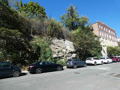
Exposed cliffs, made of schist, occur frequently in this part of the city, such as here on Cooper St. in Inwood They’re a legacy of the great glaciers that descended from the north during the last ice age and stopped at about the middle part of Long Island. Rock outcroppings that dot Manhattan and the Bronx are left over from the days when woolly mammoths and spear-carrying Cro Magnons ruled the area.
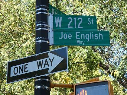
You’d be forgiven if your initial thought, if you’re familiar with the name Joe English, is that the corner here is named for the drummer for Paul McCartney and Wings for two years from 1975-1977. Despite his name, English was an American from Rochester, NY. Despite his short tenure, he played on bestsellers like Venus and Mars, Wings at the Speed of Sound and on the Wings Over America tour. Wings’ Joe English is still alive, though, and the Department of Transportation sub-names streets only for deceased local heroes. The Joe English (1940-1997) on the sign was a local crimefighter. He helped found the Inwood Patrol, a civilian patrol under the auspices of the 34th Precinct.

This masonry arch is a relic of the days when northern Manhattan was occupied by large mansions and estates. Today, it’s an un-landmarked concrete arch mostly hidden behind auto body shops (that change ownership every so often) and exists at the whim of the landlords, at Broadway near W. 215th St.
This is the last remnant of the Seaman estate: John and Valentine Seaman obtained 25 acres of land from Broadway to Spuyten Duyvil Creek and what would be W. 214th-218th Sts. in 1851 and set about building a hilltop mansion. The arch, meant as a gateway to the estate, was first built in 1855. Marble from quarries in the area was used in its construction. Evidence of a large gate, and even a room for a gatekeeper, are still in evidence at the back of the arch.
Between 1905 and 1938, the estate passed to Lawrence Drake, a Seaman nephew, and then to contractor Thomas Dwyer, who built several brick buildings on the site and razed the hilltop estate. Since then, it has served as a relic of the Seaman’s once grand domain, but it’s been left to deteriorate. Periodically it is shored up with a new paint job that quickly becomes graffiti’ed over again. The Seamans are also remembered by a lengthy avenue in Inwood.
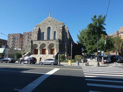
The first Good Shepherd Catholic church was a wood frame building that was moved across Cooper Street around 1930 and later razed to make way for an addition to the elementary school. When the IND subway reached Inwood in the early-1930s, the population increased, necessitating a bigger church, and the present Romanesque church was built on Broadway and Isham St. in 1935 from Fordham gneiss mined in Manhattan and Bronx quarries. Originally established to minister to Inwood’s Irish community, the Church of the Good Shepherd of today, with the aid of the Capuchin Franciscan Friars, Province of St. Mary serves a largely Hispanic congregation.
A pair of beams from the World Trade Center, fashioned in the shape of a cross, can be seen as a tribute to the responders to the 9/11 Word Trade Center destruction on the Isham Street side of the church.
—Kevin Walsh is the webmaster of the award-winning website Forgotten NY, and the author of the books Forgotten New York (HarperCollins, 2006) and also, with the Greater Astoria Historical Society, Forgotten Queens (Arcadia, 2013)